Pre-feasibility environmental review of available literature and marine data
Seabed NSW (part of the NSW Department of Planning & Environment) used LiDAR and multi-beam bathymetric surveys between July and November 2018 to produce statewide maps of landforms and seabed classifications (Ingleton, 2022; NSW Department of Climate Change, Energy, the Environment and Water, 2019, 2021, 2022, 2024a). In line with the Lean & Peat (1972) survey, LiDAR bathymetry results showed a sloping profile extending to a relatively flat area approximately 20m below sea level.
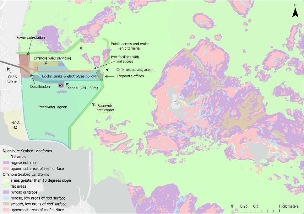
To provide baseline data on seabed shape, complexity, and composition, Seabed NSW also used standardised methods of classification to model seabed landforms and composition (substrates, habitat, and geomorphology) from LiDAR and multi-beam bathymetric survey data (Linklater et al., 2019; NSW Department of Climate Change, Energy, the Environment and Water, 2022). Wollongong was one of the areas where the model was ground-truthed, meaning modelled seabed landforms were supported by field surveys for high confidence in the model’s accuracy.
The model identified five small rugose outcrops on the project area’s sandy bottom, including two in the lower reservoir (Fig. 4). These make up approximately 2.6% of the proposed project area.
Cited References
- Ingleton, T.
Coastal Management: State-wide Marine LiDAR for New South Wales (2022)
NSW Coastal Conference, Kingscliff, New South Wales - Lean, J., & Peat, C.
Offshore geophysical and geological investigations between Wollongong Head and Port Kembla (1972)
Geological Survey Report, Issue. D. o. M. Geological Survey of New South Wales - Linklater, M., Ingleton, T. C., Kinsela, M. A., Morris, B. D., Allen, K. M., Sutherland, M. D., & Hanslow, D. J.
Techniques for Classifying Seabed Morphology and Composition on a Subtropical-Temperate Continental Shelf (2019)
Geosciences, 9(3) - NSW Department of Climate Change, Energy, the Environment and Water
NSW Marine LiDAR Topo-Bathy 2018 Geotif (2019)
NSW State Government - NSW Department of Climate Change, Energy, the Environment and Water
NSW Environment Multi Beam Echo Sounder Gridded Data (2021)
NSW State Government - NSW Department of Climate Change, Energy, the Environment and Water
NSW Seabed Landforms Derived from Marine LiDAR Data (2022)
NSW State Government - NSW Department of Climate Change, Energy, the Environment and Water
High Ecological Value Aquatic Ecosystem (HEVAE) Instream Value of freshwater rivers in NSW (2024a)
NSW State Government